Connecticut Resources

Connecticut Resources

CT Definition of Brownfields: "Sites, once used for industrial, manufacturing, or commercial uses, have been abandoned or underutilized due to known or suspected contamination from past uses. Unknown environmental liabilities have been preventing communities, developers and investors from restoring these properties to productive use and revitalizing impacted neighborhoods."

The Office of Brownfield Remediation and Development (OBRD) under the CT Department of Economic and Community Development provides financial and technical assistance. This page includes information on a variety of funding and liability relief programs offered by the state. 

State Funding Program: the state regularly announces grant and loan brownfield programs. Open solicitations and a tentative schedule for future solicitations are found on the OBRD main page. For more details, refer to this CT Funding Fact Sheet. 

Liability Relief Program: Connecticut has several liability relief programs covering both municipalities and private owners and prospective purchasers; an overview is available in the Fact Sheet and further information on the DECD website.  

The CT Department of Energy and Environmental Protection (DEEP) also provides technical support and resources for brownfield redevelopment. 
Partners in Network

State Contact Information and Resources

Organization Name Contact Role Roundtable Resource
Connecticut's Department of Economic and Community Development (CT DECD) Binu Chandy

(Office of Brownfields Remediation and Development)

binu.chandy@ct-gov The Office provides a “one-stop” state resource for information on the programs and services available for brownfield redevelopment in Connecticut. CT DECD Roundtable
Connecticut's Department of Energy and Environmental Protection (CT DEEP) Amanda Limacher

(State Brownfields Coordinator)

amanda.limacher@ct.gov A State Brownfields Coordinator manages and supports state brownfield programs by providing regulatory guidance, technical assistance, and funding coordination to facilitate the assessment, cleanup, and redevelopment of contaminated or underutilized properties.

Regional Contact Information and Resources

Council of Governments (COG) serves as a regional coordinator and facilitator, helping multiple local governments work together on assessment, cleanup, and redevelopment of brownfield sites. COGs often manage or support EPA brownfields grants, provide technical assistance, share data and best practices, and align brownfield projects with regional planning, transportation, housing, and economic development goals.

Organization Name Contact Roundtable Resource
Western CT COG Betsy Paynter bpaynter@westcog.org
Naugatuck Valley COG Ricardo Rodriguez rrodriguez@nvcogct.gov NVCOG-Roundtable.pdf
Capitol Region COG Caitlin Palmer cpalmer@crcog.org CRCOG-Roundtable.pdf
South Central Region COG Carl Amento camento@scrcog.org SCRCOG-Roundtable.pdf
Lower CT River Valley COG Sam Gold sgold@rivercog.org RiverCOG-Roundtable.pdf
CT Metropolitan COG Hannah Reichle hreichle@ctmetro.org MetroCOG-Roundtable.pdf
Southeastern CT COG Amanda Kennedy akennedy@seccog.org
Northeastern CT COG John Filchak john.filchak@neccog.org NECCOG-Roundtable.pdf
Northwest Hills COG Rista Malanca rmalanca@northtwesthillscog.org
Sustainable CT Dorothy Pisczek dorothy.p@sustainableCT.org

Non-profit Organization

Organization Name Contact Roundtable Resource
Sustainable CT Dorothy Pisczek dorothy.p@sustainableCT.org

Brownfield Inventory

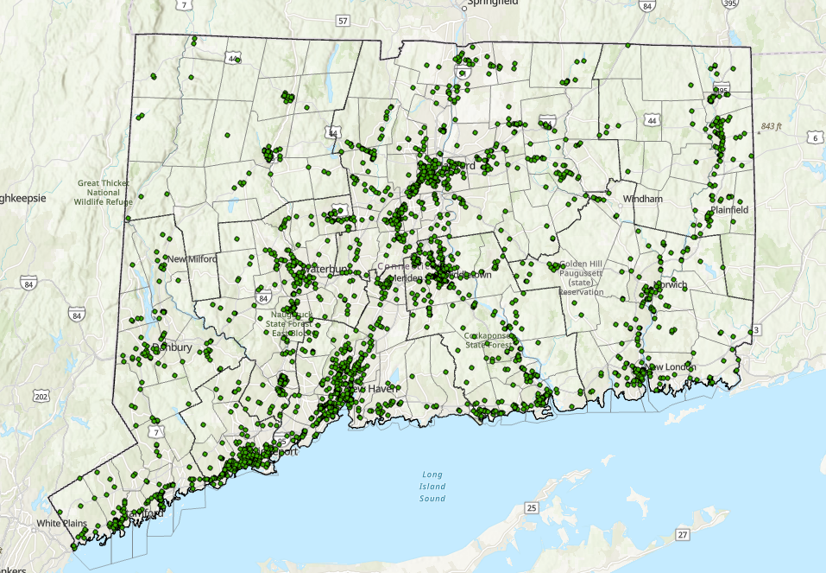
CT DEEP maintains a brownfields inventory that includes sites that have entered federal or state programs. 


Where can I find environmental standards and land use plans?

Regulatory Framework

Source: Connecticut Department of Energy &amp Environmental Protection

Provides Connecticut’s Remediation Standard Regulations (RSRs), including cleanup standards and requirements for addressing environmental contamination in soil and groundwater. The page also includes related guidance, variances, criteria, and information on proposed RSR revisions.

🔗 Click to see

State Plan of Conservation and Development

Source: Connecticut Office of Policy and Management (OPM)

Provides Connecticut’s statewide Plan of Conservation and Development, which establishes policies and priorities to guide land use, infrastructure, economic development, conservation, and other planning activities across the state.

🔗Click to see

Municipal Plans of Conservation and Development

Source: Connecticut Office of Policy and Management (OPM)

Provides access to municipal Plans of Conservation and Development (POCDs), which guide local land use, development, conservation, and community planning. Municipalities are required under Section 8-23 of the Connecticut General Statutes to prepare, amend, and adopt a POCD.

🔗 Click to see

Where can I get GIS, geographic, and regional data?

Connecticut Regional Councils of Governments

Source: Connecticut Office of Policy and Management (OPM)

Provides statewide geographic and environmental data, maps, and GIS resources covering a wide range of topics relevant to land use, natural resources, environmental conditions, and community planning.

🔗 Click to see

Where can I find general public health and socioeconomic data?

CT Department of Public Health Research and Statistics

Source: Connecticut Department of Public Health (DPH)

Provides access to Connecticut public health data, reports, statistics, and research resources, including health information available at the town level to support community health assessments and planning.

🔗 Click to see

CT Public Health Data Explorer

Source: Connecticut Department of Public Health (DPH)

Provides an interactive tool for exploring public and environmental health data, including health indicators and related datasets. Data is primarily available at the county level.

🔗 Click to see

State and National Health Data (Excel)

Source: UConn Technical Assistance to Brownfields (TAB) Program

Provides socioeconomic and health data resources relevant to EPA Brownfields Grant applications, including information that can support community needs assessments and grant proposal development.

🔗 Click to see

CDC National Environmental Public Health Tracking Network

Source: Centers for Disease Control and Prevention (CDC)

Provides interactive maps and data tools for exploring environmental and public health indicators. The Data Explorer includes cancer-related indicators available by census tract, including modeled estimates of adult cancer prevalence and breast cancer cases over a 10-year period. These estimates are based on survey data and the CDC PLACES project and are not actual cancer rates.

🔗 Click to see

Need help with cancer data and statistics?

United States Cancer Statistics

Source: Centers for Disease Control and Prevention (CDC)

Provides national cancer data visualizations, including actual cancer incidence and mortality rates available at the county and congressional district levels.

🔗 Click to see

NIH State Cancer Profiles

Source: National Cancer Institute (NCI), National Institutes of Health (NIH)

Provides county- and health service area-level cancer statistics, including data on different cancer types and the latest five-year average rates to support cancer surveillance and community health assessments.

🔗 Click to see

Looking for specific disease or health condition tracking?

Asthma Surveillance Maps

Source: Connecticut Department of Public Health (DPH)

Provides asthma surveillance data by census tract, including emergency department visits and hospitalization rates. The resource includes GIS-based maps for examining geographic patterns in asthma-related health outcomes.

🔗 Click to see

Asthma Explorer

Source: Connecticut Department of Public Health (DPH)

Provides an interactive tool for exploring asthma-related health data and geographic patterns across Connecticut communities.

🔗 Click to see

Birth Defects Data – CDC National Environmental Public Health Tracking Network

Source: Centers for Disease Control and Prevention (CDC)

Provides county-level data on 12 types of birth defects through the National Environmental Public Health Tracking Network, supporting analysis of birth defect patterns and community health conditions.

🔗 Click to see

CT Childhood Lead Poisoning Surveillance Report

Source: Connecticut Department of Public Health (DPH)

Provides Connecticut childhood lead poisoning surveillance data, including information on blood lead testing, elevated blood lead levels, and geographic patterns of childhood lead exposure.

🔗 Click to see